

SANDS FROM ĐURĐEVEC
Geo-botanical Reserve was created by applying a sediment with glacier.
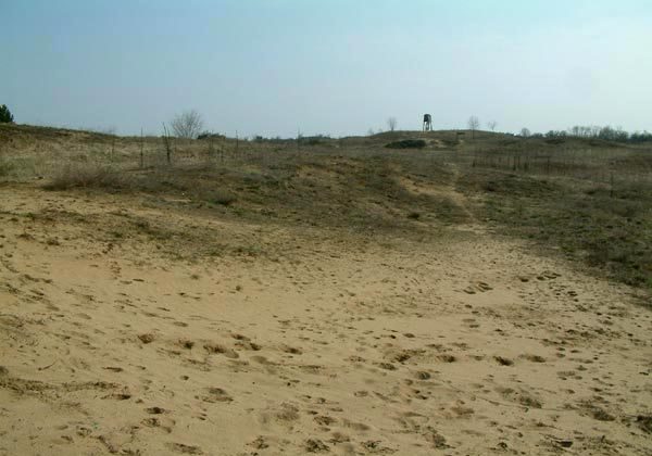
"Bloody sand", "Croatia Sahara," some of the odd names for geographic-botanical reserve Đurđevački sand or as they called Podravka Đurđevečke foot.
The resulting sediments are causing glaciers. The geographical and climatic conditions are favorable for retaining the sand in this area. By the end of the 19.century here were still "live" sand. The first work on afforestation sands begin the 1891st on the initiative of the then head of the "People's of the economic department of the Royal Government" Mirko Esq. Halper Siget.
Since then they changed scientific thinking, so the decision of the Ban Subdivisions Croatian authorities, the Department of Forestry of 17 10th 1939th The no. 14961/7-39. This area was declared a permanent protective forest, and following the prescribed method of, quote: "In the forest management unit" Đurđevački sands "locust stands can be cut clear cut. For forest red and white pine is determined by a rotation of 80 years, and has a way of cutting be seeing cut the regeneration period of 20 years, in which time is completely secure natural regeneration. "Decision is still prohibited from grazing, grass harvesting, collection of cones and needles, removing stumps and sprouts, and determined that the wood from the forest has to export the car or the amount.
Part sands proclaimed in 1963. The special geographical and botanical reserve as an easily recognizable and unique habitats in Croatia, with a view to preserving the great diversity of vegetation where the living conditions in the sand could develop and customize only certain plant species, the sand forms with unique special dynamics. Đurđevečki sands entered in 2006. within the framework of the CARDS project, and according to the effective protection of small protected areas NATURA 2000 in a pilot project of conservation.
Image gallery Order photographs
Location
Tel: +385 ( 48 ) 812-046
Coordinates: 46.06144000, 17.07485700 How to get there?
By clicking "How to get there" Google maps will open. Insert your starting adress and click "Get directions". A datailed printable plan will appear.


