Reduce font size Increase font size
  • Hrvatski
  • VIKENDPLANER.info
  • Archive
    • NuH 2012
    • NuH 2013
    • See the brochure
  • Contakt
  • Add to favorites
  • Homepage
  • Search

  • Istria
    • Istria county
  • Kvarner
    • Primorje - Gorski Kotar county
  • Dalmatia - Zadar
    • Zadar county
  • Dalmatia - Šibenik
    • Šibenik - Knin county
  • Dalmatia - Split
    • Split - Dalmatia county
  • Dalmatia - Dubrovnik
    • Dubrovnik - Neretva county
  • Lika and Karlovac
    • Lika -Senj county
    • Karlovac county
  • Central Croatia
    • Sisak - Moslavina county
    • Bjelovar - Bilogora county
  • Zagreb and surroundings
    • City of Zagreb
    • Zagreb county
  • Northern Croatia
    • Krapina - Zagorje county
    • Varaždin county
    • Međimurje county
    • Koprivnica - Križevci county
  • Slavonia - West
    • Brod - Posavina county
    • Požega - Slavonia county
    • Virovitica - Podravina county
  • Slavonia - Srijem and Baranja
    • Vukovar - Srymia county
    • Osijek - Baranja county
My plan

You have ideas: 0

View the plan
Sign up!
Sign up!
Weather forecast
°C More...
prize game
  • » Vote for the best in your county and win a perfect weekend for two!
Newsletter
Show The Best in Croatia on Google map
  • Nature
  • History
  • People
  • Events
  • Culture
  • Sport
  • Restaurants
  • Hotels
  • Fun&Party
  • Shopping
  • Products
  • i
Central Croatia » Bjelovar - Bilogora county » Nature
«»

MOUNTAIN BILOGORA

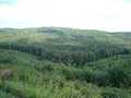
By its height Bilogora is the lowest, but one of the largest expanse of croatian mountains.

50,00 %
Add to My plan
Ideas for weekend

Bilogora is a large low mountains in northern Croatia. It consists of a series of mounds and hills, and short rounded weir was low and the head, which stretch along the southwestern edge of the Drava from the northwest to the southeast, a distance of about 80 km, with the highest forested peak; Rajčević 309 m Bilogora By its height is the lowest but one of the largest expanse of our mountains. Although in geographical terms among the downs, because of its location amid the vast plains quite noticeable. It is proper relief. Its clearly stated any slopes gently to the south side, a little steeper on the north side. Switch between the Sava and Drava basins shared by Bilogorska Podravina Lonja-Čazmanska Basin. On the southern slopes of Bilogora its offer until Moslavačke mountain.

  • Send inquiry
  • Forward to friend
  • Print
  • Comments
0

To send an inquiry/reservation of accommodation fill in the following form
Choose the dates


Refresh image

Only registrated users can comment To comment you must register. To register follow the link "Log in". If you do not have a username, please registrate using the link "Sign up".

All comments: 0


Refresh image

Location

Adresa: Info: www.tzbbz.hr

Coordinates: 45.90012360, 16.84431267
How to get there?

By clicking "How to get there" Google maps will open. Insert your starting adress and click "Get directions". A datailed printable plan will appear.

0
Share
Add to My plan
© VIKENDPLANER.info - All rights reserved
VIKENDPLANER.info