Reduce font size Increase font size
  • Hrvatski
  • VIKENDPLANER.info
  • Archive
    • NuH 2012
    • NuH 2013
    • See the brochure
  • Contakt
  • Add to favorites
  • Homepage
  • Search

  • Istria
    • Istria county
  • Kvarner
    • Primorje - Gorski Kotar county
  • Dalmatia - Zadar
    • Zadar county
  • Dalmatia - Šibenik
    • Šibenik - Knin county
  • Dalmatia - Split
    • Split - Dalmatia county
  • Dalmatia - Dubrovnik
    • Dubrovnik - Neretva county
  • Lika and Karlovac
    • Lika -Senj county
    • Karlovac county
  • Central Croatia
    • Sisak - Moslavina county
    • Bjelovar - Bilogora county
  • Zagreb and surroundings
    • City of Zagreb
    • Zagreb county
  • Northern Croatia
    • Krapina - Zagorje county
    • Varaždin county
    • Međimurje county
    • Koprivnica - Križevci county
  • Slavonia - West
    • Brod - Posavina county
    • Požega - Slavonia county
    • Virovitica - Podravina county
  • Slavonia - Srijem and Baranja
    • Vukovar - Srymia county
    • Osijek - Baranja county
My plan

You have ideas: 0

View the plan
Sign up!
Sign up!
Weather forecast
°C More...
prize game
  • » Vote for the best in your county and win a perfect weekend for two!
Newsletter
Show The Best in Croatia on Google map
  • Nature
  • History
  • People
  • Events
  • Culture
  • Sport
  • Restaurants
  • Hotels
  • Fun&Party
  • Shopping
  • Products
  • i
Central Croatia » Bjelovar - Bilogora county » Nature
«»

RIVER ČESMA

Confluence fan of river Česma is shaped and formed by numerous streams rising on the slopes of Bilogora and Moslavačka mountain. The southern slopes gently descend Bilogora, rugged numerous streams and gullies, steep and deep.

12,50 %
Add to My plan
Ideas for weekend

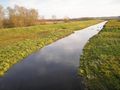
Confluence fan of river Česma is formed by numerous streams rising on the slopes of Bilogora and Moslavačka mountain. The southern slopes gently descend Bilogora, rugged numerous streams and gullies, steep and deep. The slopes have a lot of resources, which in the dry part of the lost water.
The area around the river Česma up to a hundred years ago it was subject to flooding which is why it was marshy. Then the fountain and its tributaries channeled, levees were built for flood protection, and the soil is dried to obtain arable land as well as the fight against malaria. At the site of former wetlands now are ponds that are fed by water from the streams that flow into the fountain. These ponds are one of the last waterfowl refuge between the Drava and Sava.

  • Send inquiry
  • Forward to friend
  • Print
  • Comments
0

To send an inquiry/reservation of accommodation fill in the following form
Choose the dates


Refresh image

Only registrated users can comment To comment you must register. To register follow the link "Log in". If you do not have a username, please registrate using the link "Sign up".

All comments: 0


Refresh image

Location

Adresa: Info: www.tzbbz.hr

Coordinates: 45.90018463, 16.84431267
How to get there?

By clicking "How to get there" Google maps will open. Insert your starting adress and click "Get directions". A datailed printable plan will appear.

0
Share
Add to My plan
© VIKENDPLANER.info - All rights reserved
VIKENDPLANER.info