

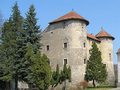
THE FRANKOPAN CASTLE IN OGULIN
Frankopan castle was built around 1500. year.
Floor plan of the building is shaped like an irregular quadrilateral, and the city for its contents belong to the type of the Renaissance castle. Between the 1835th - 1840th in Frankopan citadel were carried streets and main square of the city, under what later developed suburb.
City walls with towers and semi omeđivali the courtyard on three sides, while the fourth, Southeast, is the palace, whose three-storey building on the edges of two half round balls with Gothic features.
Legend of Djula
Djula located in the center of Ogulin. Depth of 40 meters. It ends with a picturesque gorge of the river Good to disappear into the depths of the country under a rock cliff. Over the cliff is located frakopan Town Orange (New Frankopan Castle) was built in the early 16th century. Djula receives flood waters of the well when the water level rises in the canyon. Hikers and tourists this hydrogeological nature monument can see the two gazebos that are located near the Frankopan Castle and others opposed him in the park scouts. Stone cliffs Djula often training ground for mountaineers, and the underworld Ogulin attracts speleologists.
According to legend, which dates from the first half of the 16th century and has since lived in the minds of many generations Ogulin, the abyss of the river in good Ogulin named after a young girl, whose name was Gyula or Zulejka. Zulejka girl was the daughter of John Esq. Gušić, Ogulin commander of the fortress. Parents, as was the custom of that time, vowed Zulejku older nobleman for a woman. However, in Ogulin soon arrived and the brave young captain Krajina Milan Juraic. Zulejka in love with him, but Milan was soon killed in battle with the Turks. Hearing this, or Zulejka Dula, threw herself into the abyss of the river Dobra. Thus the gulf named Djula. I looked better cliff above the abyss, one can see the profile man looking towards the great abyss of a dark hole. Ogulin say that it looks at Milan where he was missing his Zulejka.
Location
Coordinates: 45.26716609, 15.22499442 How to get there?
By clicking "How to get there" Google maps will open. Insert your starting adress and click "Get directions". A datailed printable plan will appear.


